
Days 153 to 156 - The Finale Begins in LA

Los Angeles was on fire. I drove into LA three weeks ago-- the city where Adam Watson, close friend from high school and Hollywood videographer lived, and the city of a guy's weekend before hiking "the finale", the 200-mile, world-famous John Muir Trail through the high Sierra Nevada mountains, the beautiful range of light. 

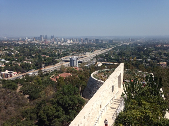
A stop at Adam's house for pre-hike laundry, camper conversion and bro catch-up was preceded by a trip to The Getty. Museums make cities pretty again. 

Zoli Brown, high school bud and big-tobacco-turned-public-safety law defender, arrived the next morning and Bob Massengale, high school bud and landscape-designer/artist/social-activist arrived that night. We reminisced over drinks and great food all night. 

Then we went for an LA adventure best described as strangely beautiful. We hit up an LA swap meet in search a wide-brim hat for Bob for the hike. Bob found his hat while I landed some elderly-ific sunglasses and a Mexican guitarist CD for mood music. 

Then on route to our next destination, the birthplace of Mr. Ed, we saw a palm tree burst into flames on the 101 highway. What?!  Drought. Foreshadowing?

Then we saw this...

Mesmerized by randomness, we continued on to a giant orange grove inside the city, where we encountered a hundred frogs in a small lake and a duck under a bench. Adam took a Facebook cover-worthy selfie with the animal. 

Not satisfied with such hilarious moments, the four of us continued on to the Shrine of Yogahanda, a famous guru of the self-realization institute- the guru to Steve Jobs and many others. We visited In-n-Out, the delicious west coast burger joint, and Santa Monica, the packed beachside haven of roller skaters everywhere.  Blade Runner was watched and a dive bar visited. A jam-packed LA day. 

We visited Venice Beach the next day and were amazed by the warm water. We rode the waves for a half hour. People buzzed around. 

Then Bob and I had to leave. We did a gear check that morning- we had most everything-- but Bob's pack would be heavy. Then Bob and I drove three hours northeast to Lone Pine, California. We checked into our hotel, did a final backpack packing, and went to bed. We had to catch a 6:15am bus the next morning north to Yosemite and our 200-mile adventure. Excited but nervous, we fell asleep. 

Comments

Popular posts from this blog

Day 104 - Glacier to Vancouver

The hike up Balu Pass was supposed to be fairly easy, beautiful and dotted with waterfalls, but when I talked to the park ranger and learned that Vancouver was an eight hour drive away, I decided to skip Balu and drive west.  I left behind this pretty view.  And drove many hours through pristine mountains, fewer and fewer snow-capped ones the further west I drove. Some of the valleys were flooded to make reservoirs, leaving scenic sights.  I eventually made it to Vancouver and drove right on through to Point Roberts USA, a five mile by five mile coastal land just below the 49th parallel and thus in the USA. The park ranger had suggested this as a good place to camp but being late of the Thursday night before the Fourth of July there were no spots available. I drove around instead and stopped at a forested coastal park. After ten minutes of walking I came to my first grand Pacific view with Mount Baker 60 miles east.  The San Juan Islands and Orca Islands could also b...

Day 122 - Mount Saint Helens

Mount Saint Helens is sinister and wonderful. I spent the morning at Rainier watching the end of the British Open on my phone, then drove south to Saint Helens.  I arrived at the park's northeast entrance by early afternoon.  A massive bulge of rock built up on the northeast side of the mountain before the 1980 eruption and then caused a tremendous landslide when the eruption started. I drove to the Windy Ridge at the end of the road, listened to a ranger describe before and after photos of the mountain, then hiked up to a high viewpoint.  You can see the circular ridge with a notch missing where the landslide occurred, the desert-like exposed right-side where the landslide blew away life and covered 15 miles of terrain with 150 feet of dirt and rock, the greenery that was on the lucky side of the eruption, and Spirit Lake which was covered by dirt and slime and fallen trees for years. The mountain was over a thousand feet higher before it erupted.  After taking in t...

Day 62 - Colorado National Monument

Established as a national monument early in 1911, Colorado NM is known for its high canyon "rim road" and sandstone spires of Monument Canyon.  The canyons of west Colorado are pretty--as they have more green trees and shrubs than the more famous Utah canyons. This gives them a more alive feeling, although the sandstone spires were formed many thousands of years ago by erosion.  Rim Rock road curves up the the top of the canyon cliff, goes through several round tunnels and is lined with scenic viewpoints. The best views were in he Monument Canyon section, and included in sequence, the Coke Ovens, The Kissing Couple (behind my head), and the most famous of all: Independence Monument, the tall spire in pic 3 and viewed from the side in pic 4.  The original promoter and caretaker of the park, John Otto, was the first person to climb Independence Monument and now it's a climbing right of passage. Every July 4 climbers ascend and mount an American flag at the summit. Fun! ...