
Day 48 - Dead Horse Point

Cowboys used to corral horses beyond the narrow neck of this high point overlooking the Colorado River.  They would then fence them in and when they returned take the strongest horses and leave the weaker ones to die without water at this to-be-named Dead Horse Point State Park. Terrible name and story, great views. 

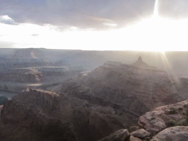
500 feet higher in elevation than the just-across-the-canyon Canyonlands Island in the Sky, Dead Horse Point does have a must-see view of the mighty Colorado and vast canyons behind. I arrived mid-afternoon and hiked the east rim trail a mile and a half to the far point, meandered along the west rim a bit and then hiked back along the road. 

Knowing sunset time was special in this canyon country, I decided to wait a bit for the sun to fall. I drove this time to the far point, then walked around in search of the best vantage point. 

Before the sun actually set, I drove on, first to a full closeby campground and then on an hour to Moab, to the campground from the prior days. Surprised that this 128 unit campground was full and disappointed as it was definitely dark, I pulled up a free campsite location on GPS down the highway outside of town and drove. I arrived at this dirt open space just off the highway, just before a gate leading to an off-road track. I didn't love the spot as it was exposed and near the highway, but it would have to do for the night.


Comments

  1. Not sure if my last comment posted --- just wanted to say I love these photos and am inspired by your adventures!

    ReplyDelete
    Replies
    1. Hey Esther- yes, comment received! I'm glad you enjoy the blog. I remember you said you had a things for small spaces living- a passenger van fits that bill!

      Delete

Post a Comment

Popular posts from this blog

Day 57 - Rocky Mountain National Park

Ever since I decided to go west for my big trip, I had dreamed of high mountain lakes with snowy peaks arching in every direction, with chilly air making every moment crisp, and with clear skies bringing all into perfect focus-- pure bliss.  Today was the first of many great mountain lake days to come.  Hiking here was far easier here than in the San Juans because the snow was packed down on the trail, but I brought my mini crampons for the downhill. I made it safely past a narrow ridge with narly black peaks across the gorge (pic 1), then up to Mills Lake (pic 2) then Jewel Lake then the Loch (pic 3) then down before the afternoon rain started falling.  I hiked around some lower, more accessible lakes but the sky was now overcast and pictures no good.  I drove up the open portion of the Ridge road amid a very light dusting of snow before heading back to camp for dinner and bedtime. I did manage to capture some fine Elk grazing in a meadows on the return trip and a g...

Day 43 - Capitol Reef

Capitol Reef, a national park centered around a 90 mile ancient seabed reef was next on my list. A sensationally scenic three hour drive from Bryce, back through Escalante, and then through a national forest led me to the park.  A stop by the visitor center to get the lay of the land and insider info on local free BLM campsites complete, I set out on Chimney Rock trail up the the top of the first reef to get a view.  Yes sir!! The weather was ideal for hiking and the views completely blissful, but I was frankly tired today. I set out along the scenic road down the west side of the reef and remember wanting to take a nap-- but still having a sense of urgency to complete the desert portion of my trip-- I pushed on and set out to hike down the Capitol Gorge and Grand Wash canyons. The Capitol Gorge had a "Pioneer Wall" with inscriptions from the early 1900s and the Grand Wash had a nice narrow section with towering canyon cliffs all around. I took a photo of the surrounding reef...

Day 54 - Great Sand Dunes

I awoke to clear skies, a dry mattress and pillows, a second hot shower and a waffle-filled motel breakfast. I decided to head east to Great Sand Dunes National Park in order to climb 700 foot sand dunes surrounded by snow-covered alpine mountains--a rare site.  Just about every road in Colorado goes over a pretty high mountain pass eventually, and this three and a half hour journey didn't disappoint.  And Great Sand Dunes didn't disappoint either. After securing a dune-side campsite and waiting out a rainstorm, I set out to climb the dunes for a sunset view. Great Sand Dunes is also famous for its Medano Creek wave-like flow and ankle-deep water, making it popular with young kids. I hiked through it and started climbing the dunes, first to a high dune on the east side and over to the next highest dune and then the next highest et until I got to the highest one-/ properly called High Dune. I sat down, setup my phone to capture a time-lapse of the beautiful sunset my eyes were ...