
Day 171 - JMT Guitar Lake

Wow, was it cold this morning. After waking up and eating breakfast, we packed up quickly and found this scenic sunspot to warm our bones. We had a short eight mile hike to Guitar Lake today,  the last viable campsite before the five mile hike to the 14,505 foot-high Mount Whitney summit. 

We stopped at this lovely meadow and looked for bears. We only saw deer but were able to enjoy the incredible peace of the far mountain range. Steady hiker traffic, the most of the entire trip, including one group of twelve elder hikers, passed us as we rested, and jumped!

Views of Mount Whitney finally came into view at Timberline Lake, a quaint lake where camping was unfortunately forbidden. We passed a group of twenty Taiwanese hikers. 

The summit of Mount Whitney looked heavily defended when viewed from below. We were going to wake up tomorrow at 230am and hike up to the summit for sunrise-on-the-top-of-the-world*. The thought of this dark task was a bit foreboding. 

We made it to Guitar Lake by lunchtime and looked for an unexposed campsite amid the treeless, 11,500 foot high terrain. We found a great campsite with large boulders on three sides and a foot tall wall of stacked rocks on the fourth side, located just above Guitar Lake at the last water before Whitney. The view of the guitar-shaped lake and the mountain range beyond was epic, truly epic. 

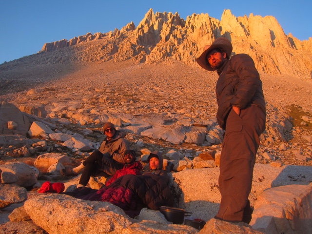
We met three super-cool hikers at Guitar Lake: accountant/climber Sky and programmer/adventurer Meresh from San Francisco and musician Jess from Montana. We passed the lazy afternoon by swimming in the ice cold tarn, journaling, eating as much remaining food as possible to cut weight, and exchanging stories. We ate dinner as a group as the sun went down. 

Jess played his soulful folk music as the sun slowly faded on our last night in the High Sierra. Two other couples came over, hearing the sweet music, and began to dance. 

It was, in a word, perfection. 

Comments

  1. Rocky Mountain National Park wants to do something about it. In lieu with this, the National Park Service together with the. rocky mountain air

    ReplyDelete

Post a Comment

Popular posts from this blog

Day 161 - JMT Purple Lake and Tully Hole

We got our first glimpse of smoke far across the valley as we climbed higher. Up on a ridge after a morning climb, we followed a side trail to an open viewpoint beyond the trees. Selfie:) The smoke, while visible, seemed to give the mountains a blue glow-- like a highlighter to a sketch. You could still see the edges of the mountain ridges, the story of their creation. We could hike in this. But the smoke looked worse farther south. Or it was getting worse as time rolled incessantly forward.  On day two we had ran into a northbound hiker we nicknamed Speedy Steve. Speedy Steve had hiked 18 miles a day through eight consecutive smoke-filled days, including atleast three "very bad days" when he couldn't see the surrounding mountains, the sun glowed a haunting orange and ash accumulated overnight. On the way to Purple Lake we ran into three dirty, beat up, tired north-bound hikers with a similar story. They had to spend one night in an emergency hut at Muir Pass to avoid the...

Day 48 - Canyonlands Island in the Sky Pt 2

Mountain biking the 100-mile 4x4 White Rim Road is said to be a great American adventure. But without any water, you need a follow truck to carry your water and gear, and reservations must be made three months in advance. So I just decided to hike down 1500 feet to the white rim and hike the road a bit.  Steep, steep, steep was the descent down the Goosberry trail, but I reached the rim level in only 45 minutes!  I hiked further down to the white rim road and then past to the very edge. Looking around for a possible path down to the river bottom 1000 feet below was a fun task, but a hard one as the "white rim rock" has a solid sheer 50-150 feet dropoff. I found one possible path down but a lone Nalgene bottle left down below the white rocks indicated an aborted attempt down. I continued to walk the rim for a few hours, finally climbing a small Mesa edge to enjoy the high view of the other side.  After a brief respite, I walked back an hour along the Jeep 4x4 road to the G...

Day 41 - Escalante Coyote Gulch

This one or two night Coyote Gulch hike was an easy test of my newly learned navigation skills.  Anxious to get started I awoke at 545 just as the sun was rising.  I followed an obvious landmark, a tall thin spire called Chimney Rock, northwest to Hurricane Wash (a drainage running into Coyote Gulch).  After a couple of hours of walking up over and around slick rock, I entered the famous Coyote Gulch.  The walls around me raised up, darkened and th water flow increased--like nature hinting at the scenic beauty ahead.  The normally crowded Coyote Gulch was fairly empty on this early Thursday morning, giving the canyon a very peaceful and quiet feeling-- fragile almost. Down steam, I ran into the famous Jacob Hamilton Arch and then thirty minutes further-- the Coyote Natural Birdge. Both were beautiful due to their see through the wall character, but both would be overshadowed in my memory by the Stevens Arch tomorrow. Pics.  By 1pm, I had hiked for six hours...