
Day 121 - Mount Rainier Summerland

Sunrise and Summerland were the destinations for day 2 at Rainier. Sunrise is a high valley on the northeast side of the mountain. Before heading up the sunrise road I made a detour to Chinook Pass, famous for being a pass on the Pacific Crest Trail and for its nearby lake views of Rainier. 

I drove along the road in hopes of finding elusive cell phone coverage and magically found coverage on most of the sunrise road. I drove up the long, winding road to its top and hiked out to an overlook of the Emmons Glacier, the largest glacier in the lower 48 states. 

I then returned down the road to the Summerland trailhead and made some phone calls to friends and my father to talk logistics of two separate future trips next month. I set out for Summerland at 545pm. The first three miles were boring, heading up through the woods; I contemplated turning back. Then I reached an opening and saw what the fuss was all about-- why this hike was so popular. 

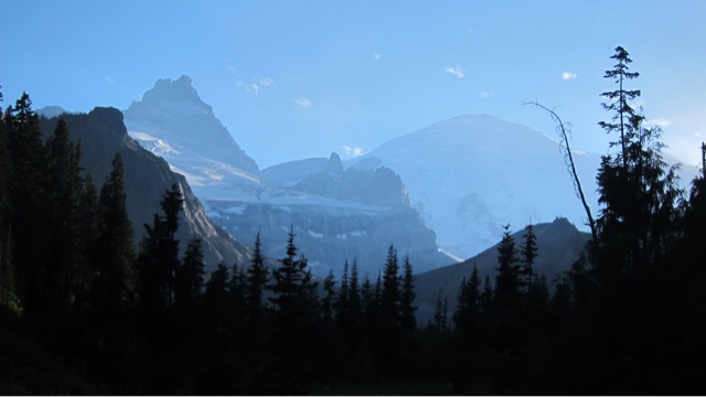
The mystic view of Rainier and the craggy Little Tahoma peak glowed in the late afternoon light. I considered waiting for sunset at this spot but instead continued up a very steep hillside to the Summerland campground. The view of Rainier and Little Tahoma was even better from here-all views get better as you get higher. I hiked past the campground to a rocky hill on the far side. It was 1.5 miles and 900 ft up to Panhandle Gap, another destination on my list, but it was now 7:45pm. 

I decided to go for it:)  I was so close and I wanted to see the view across the pass--what was on the other side? So I hiked up, through moon-like volcanic landscapes surrounded by glaciers and ever-changing glorious Mount Rainier views. I reached the Gap and looked out to the other valley: Wow wow wow wow was all I could say. Wow wow wow.  Like the hills of Tuscany but with a volcano (Mount Adams) in the background. 

I turned back at 830pm and took this celebratory photo, perhaps my favorite portrait so far, in front of a magical Rainier sunset. I hiked the final hour in total darkness with a dim headlight to light the path. I now agree with the many others: Rainier is a spiritual experience!

Comments

Popular posts from this blog

Day 43 - Capitol Reef

Capitol Reef, a national park centered around a 90 mile ancient seabed reef was next on my list. A sensationally scenic three hour drive from Bryce, back through Escalante, and then through a national forest led me to the park.  A stop by the visitor center to get the lay of the land and insider info on local free BLM campsites complete, I set out on Chimney Rock trail up the the top of the first reef to get a view.  Yes sir!! The weather was ideal for hiking and the views completely blissful, but I was frankly tired today. I set out along the scenic road down the west side of the reef and remember wanting to take a nap-- but still having a sense of urgency to complete the desert portion of my trip-- I pushed on and set out to hike down the Capitol Gorge and Grand Wash canyons. The Capitol Gorge had a "Pioneer Wall" with inscriptions from the early 1900s and the Grand Wash had a nice narrow section with towering canyon cliffs all around. I took a photo of the surrounding reef...

Day 54 - Great Sand Dunes

I awoke to clear skies, a dry mattress and pillows, a second hot shower and a waffle-filled motel breakfast. I decided to head east to Great Sand Dunes National Park in order to climb 700 foot sand dunes surrounded by snow-covered alpine mountains--a rare site.  Just about every road in Colorado goes over a pretty high mountain pass eventually, and this three and a half hour journey didn't disappoint.  And Great Sand Dunes didn't disappoint either. After securing a dune-side campsite and waiting out a rainstorm, I set out to climb the dunes for a sunset view. Great Sand Dunes is also famous for its Medano Creek wave-like flow and ankle-deep water, making it popular with young kids. I hiked through it and started climbing the dunes, first to a high dune on the east side and over to the next highest dune and then the next highest et until I got to the highest one-/ properly called High Dune. I sat down, setup my phone to capture a time-lapse of the beautiful sunset my eyes were ...

Day 67 - Badlands

Badlands means very difficult and dangerous to travel through-- Badlands lived up to this name.  I began my eight mile loop hike by climbing up a steep canyon side to the mesa wall on top. From here I travelled east towards the popular window, door and notch trails via a wet, muddy and slippery Medicine Root trail that left me covered in mud up to my knees.  Of the popular trails the notch was my favorite because it involved a wooden ladder climb and then a hill scramble past crumbling rock up to a six foot "notch" step that required a almost-rock climbing move to ascend.  The views up at the top cliff were sensational. Even more fun, two girls from New York-driving to Portland and a young couple saw me up there and followed the path up-- with a bit of my help at the notch. I love helping people get a bit beyond their comfort zone. We all enjoyed the view then descended safely to find that this notch was not actually the trail but a side canyon-- haha.  I then hiked ...